Lake Toba (Indonesian: Danau Toba) is a lake and
supervolcano. The lake is 100 kilometres long, 30 kilometres wide, and up to
505 meters (1,666 ft) deep. Located in the middle of the northern part of the
Indonesian island of Sumatra with a surface elevation of about 900 metres
(2,953 ft), the lake stretches from 2.88°N 98.52°E to 2.35°N 99.1°E. It is the
largest lake in Indonesia and the largest volcanic lake in the world.
Lake Toba is the site of a massive supervolcanic eruption
estimated at VEI 8 that occurred 69,000 to 77,000 years ago, representing a
climate-changing event. It is the largest known explosive eruption on Earth in
the last 25 million years. According to the Toba catastrophe theory, it had
global consequences for human populations: it killed most humans living at that
time and is believed to have created a population bottleneck in central east
Africa and India, which affects the genetic make up of the human world-wide
population to the present. This hypothesis is not widely accepted because
evidence is lacking for a decline or extinction of other animals, including
species that are sensitive to changes in the environment.
It has been accepted that the eruption of Toba led to a
volcanic winter with a worldwide decrease in temperature between 3 to 5 °C (5.4
to 9.0 °F), and up to 15 °C (27 °F) in higher latitudes. Additional studies in
Lake Malawi in East Africa show significant amounts of ash being deposited from
the Toba eruptions, even at that great distance, but little indication of a
significant climatic effect in East Africa.
Geology
At least four cones, four stratovolcanoes, and three craters
are visible in the lake. The Tandukbenua cone on the northwestern edge of the
caldera has only sparse vegetation, suggesting a young age of several hundred
years. Also, the Pusubukit (Hill Center) volcano (1971 meters above sea level)
on the south edge of the caldera is solfatarically active and is a Geology
Sanctuary.
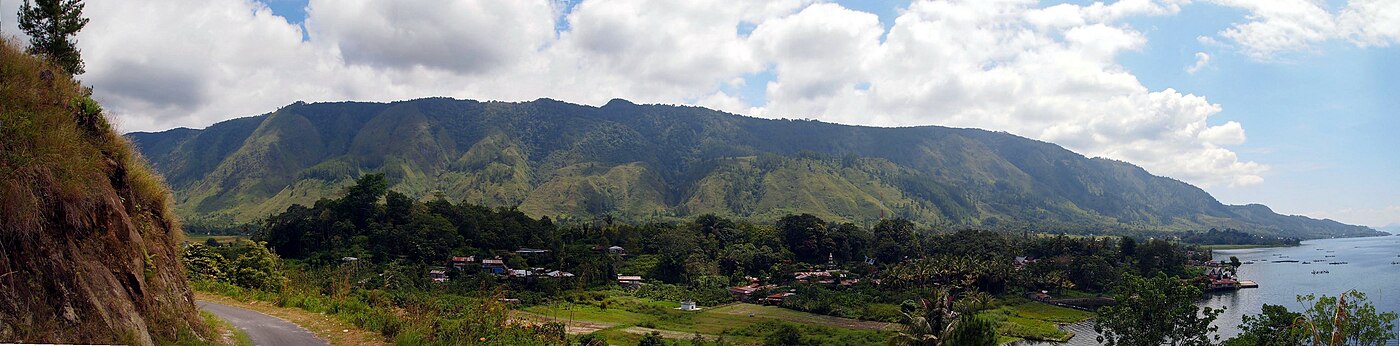
Panoramic view of the town of Ambarita on Samosir, Lake Toba
The eruption

Location of Lake Toba shown in red on map.
The Toba eruption (the Toba event) occurred at what is now
Lake Toba about 67,500 to 75,500 years ago. It was the last in a series of
at least three caldera-forming eruptions at this location, with earlier
calderas having formed around 700,000 and 840,000 years ago. This last eruption
had an estimated VEI 8, making it possibly the largest explosive volcanic
eruption within the last 25 million years.
Bill Rose and Craig Chesner of Michigan Technological
University have estimated that the total amount of material released in the
eruption was about 2,800 km3 (670 cu mi)[12]—about 2,000 km3 (480 cu mi) of
ignimbrite that flowed over the ground, and approximately 800 km3 (190 cu mi)
that fell as ash mostly to the west. The pyroclastic flows of the eruption
destroyed an area of 20,000 km2 (7,722 sq mi), with ash deposits as thick as
600 m (1,969 ft) by the main vent.
The eruption was large enough to have deposited an ash layer
approximately 15 cm (5.9 in) thick over all of South Asia; at one site in
central India, the Toba ash layer today is up to 6 m (20 ft) thick[13] and
parts of Malaysia were covered with 9 m (30 ft) of ash fall. In addition it has
been variously calculated that 10,000 million tonnes (1.1×10¹⁰ short tons) of
sulfurous acid or 6,000 million tonnes (6.6×10⁹ short tons) of sulfur
dioxide[16] were ejected into the atmosphere by the event.
The subsequent collapse formed a caldera that, after filling
with water, created Lake Toba. The island in the center of the lake is formed
by a resurgent dome.

Landsat photo of Sumatra surrounding Lake Toba
The exact year of the eruption is unknown, but the pattern
of ash deposits suggests that it occurred during the northern summer because
only the summer monsoon could have deposited Toba ashfall in the South China
Sea. The eruption lasted perhaps two weeks, and the ensuing "volcanic
winter" resulted in a decrease in average global temperatures by 3.0 to
3.5 °C (5 to 6 °F) for several years. Greenland ice cores record a pulse of
starkly reduced levels of organic carbon sequestration. Very few plants or
animals in southeast Asia would have survived, and it is possible that the
eruption caused a planet-wide die-off.
Evidence from studies of mitochondrial DNA suggests that
humans may have passed through a genetic bottleneck around this time that
reduced genetic diversity below what would be expected given the age of the
species. According to the Toba catastrophe theory, proposed by Stanley H.
Ambrose of the University of Illinois at Urbana-Champaign in 1998, the effects
of the Toba eruption may have decreased the size of human populations to only a
few tens of thousands of individuals. However, this hypothesis is not widely
accepted because similar effects on other animal species have not been
observed.
Since the major eruption ~70,000 years ago, eruptions of
smaller magnitude have also occurred at Toba. The small cone of Pusukbukit
formed on the southwestern margin of the caldera and lava domes. The most
recent eruption may have been at Tandukbenua on the northwestern caldera edge,
suggested by a lack of vegetation that could be due to an eruption within the
last few hundred years.
Some parts of the caldera have shown uplift due to partial
refilling of the magma chamber, for example, pushing Samosir Island and the
Uluan Peninsula above the surface of the lake. The lake sediments on Samosir
Island show that it has risen by at least 450 m (1,476 ft) since the
cataclysmic eruption. Such uplifts are common in very large calderas,
apparently due to the upward pressure of below-ground magma. Toba is probably
the largest resurgent caldera on Earth. Large earthquakes have recently
occurred in the vicinity of the volcano, notably in 1987 along the southern
shore of the lake at a depth of 11 km (6.8 mi).[20] Such earthquakes have also
been recorded in 1892, 1916, and 1920–1922.
Lake Toba lies near the Great Sumatran fault, which runs
along the centre of Sumatra in the Sumatra Fracture Zone. The volcanoes of
Sumatra and Java are part of the Sunda Arc, a result of the northeasterly
movement of the Indo-Australian Plate, which is sliding under the
eastward-moving Eurasian Plate. The subduction zone in this area is very
active: the seabed near the west coast of Sumatra has had several major
earthquakes since 1995, including the 9.1 2004 Indian Ocean Earthquake and the
8.7 2005 Sumatra earthquake, the epicenters of which were around 300 km (190
mi) from Toba.
People
Most of the people who live around Lake Toba are ethnically
Bataks. Traditional Batak houses are noted for their distinctive roofs (which
curve upwards at each end, as a boat's hull does) and their colorful decor.
Flora and fauna
The flora of the lake includes various types of
phytoplankton, emerged macrophytes, floating macrophytes, and submerged
macrophytes, while the surrounding countryside is rainforest including areas of
Sumatran tropical pine forests on the higher mountainsides.
The fauna includes several species of zooplankton and
benthic animals. Since the lake is oligotrophic (nutrient-poor), the native
fish fauna is relatively scarce, and the only endemics are Rasbora tobana
(strictly speaking near-endemic, since also found in some tributary rivers that
run into the lake) and Neolissochilus thienemanni, locally known as the Batak
fish.[24] The latter species is threatened by deforestation (causing
siltation), pollution, changes in water level and the numerous fish species
that have been introduced to the lake. Other native fishes include species such
as Aplocheilus panchax, Nemacheilus pfeifferae, Homaloptera gymnogaster, Channa
gachua, Channa striata, Clarias batrachus, Barbonymus gonionotus, Barbonymus
schwanenfeldii, Danio albolineatus, Osteochilus vittatus, Puntius binotatus,
Rasbora jacobsoni, Tor tambra, Betta imbellis, Betta taeniata and Monopterus
albus. Among the many introduced species are Anabas testudineus, Oreochromis
mossambicus, Oreochromis niloticus, Ctenopharyngodon idella, Cyprinus carpio,
Osphronemus goramy, Trichogaster pectoralis, Trichopodus trichopterus, Poecilia
reticulata and Xiphophorus hellerii.

Panoramic view of Parapat from Samosir Island, Lake Toba.
0 Response to "Lake Toba"
Posting Komentar